中國軍事多維指揮所-有效網路戰行動的互動式軍事規劃沙箱
The military electronic sandbox is a modern information system platform that can grasp the three-dimensional battlefield space situation, implement efficient command, and support scientific command training. Its core is to use geographical information technology, military simulation technology, advanced display technology, etc. to replace traditional maps and sandbox tools to achieve The integrated display of geographical information and situational information allows commanders to deeply understand the combat environment. With the assistance of the command operation system, it greatly improves the command’s decision-making capabilities and response speed, and improves the quality effect of command training.
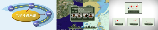
The software platform of the military interactive electronic sandbox system is the core of the electronic sandbox system. Its working principle is to access multi-source external data, integrate, process and store data, analyze data based on business needs, and dynamically display data in two or three dimensions. Therefore, the data processing platform is the foundation, and the data access platform and visual display platform are the support. The visual display terminal is the most intuitive cognitive image of the electronic sandbox, including mobile terminals, desktop terminals and large-screen display terminals. Among them, large-screen display terminals can support multi-point infrared touch and are the main form of human-computer interaction.
1. System introduction
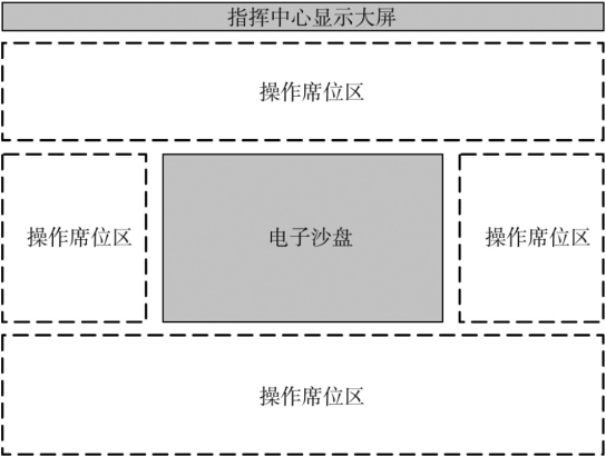
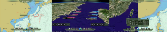
In military applications, electronic sandbox systems are generally deployed in fixed command centers or mobile command posts. They are an important part of the command training system. Their basic functions are two- and three-dimensional geographic information display and battlefield simulation.
In order to achieve the effect of stable integration of the electronic sandbox and the real environment, for example, a multi-channel interactive system is constructed based on multi-AI methods to provide commanders with a more efficient and natural interaction method, thereby improving the commander’s command efficiency. Achieve full-element, multi-category, multi-level, and multi-granularity three-dimensional real-scene holographic display, provide commanders with intuitive and realistic battlefield situation elements, and provide the ability to observe the situation from multiple perspectives and directions, helping to grasp the overall situation and ensure the smooth operation of combat missions Complete it in time to improve combat effectiveness. The military plotting electronic sandbox is based on natural interaction (including voice, movement, gesture, line of sight, etc.), augmented reality, collaborative plotting and other technologies, and allows commanding combatants with different roles to conduct virtual and real interactions and collaborative discussions in real command posts. , jointly plotting, formulating plans, etc. to provide technical support, which will become a strong driving force for the leapfrog development of electronic sandboxes.
The multi-dimensional interactive military plotting electronic sandbox developed by a company is based on a practical perspective and is compatible with the terrain description function of the traditional physical sandbox and inherits the geographical information display function of the traditional electronic sandbox. It is oriented to the combat and training needs of senior commanders and focuses on achieving Through the interconnection of the electronic sand table and other operating seats in the command center, a set of intelligent interactive command and training operating platforms are designed and proposed for command operations during wartime and for drills and drills in peacetime.
During wartime, the electronic sand table serves as the display and control terminal for the commander to command operations. It integrates the support information of combat elements at each operating seat, receives battlefield information in real time, displays two- and three-dimensional battlefield situation maps, and provides basic auxiliary means such as plotting, measurement, and calculation. At the same time, it is based on data Mining and artificial intelligence technology provide the commander with a combat plan that can be intelligently learned and adjusted and conduct deduction simulations to assist the commander in making combat decisions. In normal times, the electronic sand table serves as the command and control terminal for the chief’s training exercises. It has the functions of scenario setting and training guidance, and supports data recording, auxiliary evaluation, review deduction and historical data query in the entire process of training scenarios from formulation, deployment to training. At the same time, it can also be used as a research platform for personnel exchange and training in the command center and a service platform for the release, display, and application of military intelligence information.
The multi-dimensional interactive military plotting electronic sand table developed by a company is based on a two-dimensional geographical information platform and a three-dimensional digital earth, combining multimedia display and control technology, simulation visualization technology, network communication technology, massive data management technology and multi-touch technology. A new two- and three-dimensional interactive military simulation and simulation integrated platform.
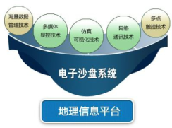
The software platform is the core of the electronic sandbox system. Its working principle is to access multi-source external data, integrate, process and store data, analyze data based on business needs, and dynamically display data in two or three dimensions. Therefore, the data processing platform is the foundation, and the data access platform and visual display platform are the support. The visual display terminal is the most intuitive cognitive image of the electronic sandbox, including mobile terminals, desktop terminals and large-screen display terminals. Among them, large-screen display terminals can support multi-point infrared touch and are the main form of human-computer interaction.

Working principle diagram of military interactive electronic sandbox system
(1) Infrastructure layer
The infrastructure layer is the basic environment that supports system operation, including graphics workstations, storage devices, computing devices, network devices, display devices, operating systems, etc. It provides a unified, high-speed, and secure basic network and host operating platform for the prototype system.
(2) Basic service layer
The basic service layer is the data resource carrying and basic service providing layer of the system. It supports the platform application layer and provides basic functions such as database management system, communication manager, and specific engines. On this basis, it develops and provides business-related basic services. Core services include geographical information services, data access services, situation display services, simulation deduction services, interconnection services, military marking services, etc. Service types can be customized and developed according to needs to meet the needs of different business applications.
(3) Platform application layer
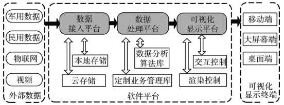
Including business platform and user-oriented application plug-ins. The business platform includes a data access platform, a data processing platform, and a visual display platform.
(4) Data access platform
It is used to access, process, store and distribute various types of information and build a customized professional military intelligence database. Specifically, it is able to receive data from different sources, formats, and characteristics on combat processes, comprehensive support, geographical information, simulations, and other data, and integrate them logically or physically to provide information for situation display, combat discussions, command decisions, training evaluation, etc. Different applications provide data support. In peacetime, all kinds of basic military information, such as equipment information, personnel information, position information, target information, combat plans, etc., are collected, processed into a data format that can be called by the data processing platform, and saved in the form of local storage or cloud storage; During wartime, the meteorological and hydrological, electromagnetic environment, geographical environment, and humanistic environment data from each operating seat of the command center, the real-time location and attributes of personnel and equipment on the battlefield, Beidou information, video information, etc. are accessed in real time and processed into a data processing platform. The data format of the call.
(5) Data processing platform
With geographical information data as the background, various types of data from the data access platform are received or called, and a situation map is constructed to realize the visualization of the enemy’s situation, our situation, battlefield environment, target analysis, action progress, plotting and intervention process. On this basis, it provides standardized interfaces to achieve effective data connection with other systems, ensures function expansion and access to other systems, supports customized development of business application plug-ins, and provides support for the expansion of combat command business. In peacetime, based on the accumulated data, a simulated battlefield situation is constructed, combat plans and plans are formulated, exercises, training and simulations are conducted, and relevant results are stored in the data access platform for use in wartime.
(6) Visual display platform
Based on the independent 3D simulation engine, real-time rendering generates a 3D battlefield environment that is consistent with the combat and training areas. It uses structured data technology and flexible and editable logical data models to realize “layered” information data fusion display and output, and realizes multiple Click on infrared touch control and voice control, etc.
(7) Platform plug-ins
Relevant plug-ins are designed to meet the needs of operational planning, including functional plug-ins for data connection and management, process analysis and display, and program deduction and evaluation. They are customized to realize the connection and comprehensive management of operational planning business data. A “one picture” comprehensive display of the battlefield environment and battlefield situation during the combat process, as well as a comprehensive simulation deduction and display of various plans for reconnaissance, troop operations, battlefield defense and fire strikes involved in the combat process.
3. System composition
(1) Data engine
1. Diverse data
Supports massive, multi-source data processing, mainly including: images, vectors, DEM, 3D models, sea maps, land maps, aerial maps, etc.;
2.Data update
Supports rapid updating of multi-level mixed-precision geographical data;
3.Data distribution
Support data distribution based on C/S mode and quickly build electronic sandbox;
4.Data access
Supports distributed deployment and access of massive data from multiple sources, and can access cloud data.

(2) Comprehensive display and control
1.Full space expression
Supports full-space, multi-view, and multi-granularity simulation visual expression;
2. Two-dimensional and three-dimensional integration
Supports two- and three-dimensional integrated visual expression;
3.Multi-touch
Support new human-computer interaction methods based on multi-touch technology;
4. Interactive annotation
Supports interactive annotation of 3D models, landmarks, paths, regions, 360 panoramas and mounting of multimedia information.
(3) Sand table situation
1. Situation visualization
Supports multi-target and multi-batch battlefield situation visualization, and has functions such as scene saving and playback;
2. Diverse data sources
Compatible with multi-source surveillance data such as GPS, Beidou, radar, and AIS, and has an expandable data interface;
3. Editing and deduction
Supports 2D and 3D integrated editing and deduction of situational scenarios;
4. Situation special effects library
It has a rich library of battlefield simulation effects such as flame, explosion, smoke, infrared, electromagnetic, and radar.
(4) Military standard drawing
1. Collaborative plotting
Supports multi-person and multi-client synchronous and asynchronous collaborative military plotting;
2. Two-dimensional and three-dimensional plotting
Supports 2D and 3D simultaneous plotting and editing of military standards;
3. Sketch drawing
Supports intelligent recognition and plotting of sketches;
4.Same screen plotting
Supports multi-person 3D model plotting and editing on the same screen;
5. Military standard deduction
It has the function of 2D and 3D military standard situation deduction.

(5) Simulation engine
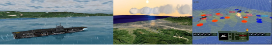
1. Natural environment simulation
Professional game-level rendering, supporting natural environment simulations such as three-dimensional clouds, fog, rain, snow, seawater, etc.;
2. Meteorological numerical simulation
Supports efficient processing, analysis and numerical simulation of large-scale, multi-source battlefield meteorological environment data;
3. Simulation deduction
Use human-computer interaction to deploy and perform deductions on deduction targets, and can expand simulation algorithms and combat rules;
4.Effectiveness evaluation
Supports assessment of operational effectiveness.
(6) Collaborative discussion
1. Electronic whiteboard
Distributed collaborative discussion and plotting based on electronic whiteboard, supporting conventional graphics, military standards, multimedia files, etc.;
2. Video conferencing
It has conference room mode collaborative discussion functions based on text, voice, and video communication to improve communication efficiency;
3. File sharing
Supports file sharing such as txt, PPT, PDF, picture files, compressed files, videos, etc.

(7) Software and hardware integration
Supports perfect integration with desktop interactive hardware;
Supports perfect integration with multi-touch hardware;
Support integration with video conferencing system hardware;
Support cross-platform applications.
(8) Key functional indicators
It has the display effects, fault simulation, and data connection functions of the existing aviation police information reconnaissance system; it has the functions of world sea and air area division display and air defense identification zone;
Have the ability to quickly configure existing business data into learning resources, and quickly configure learning resources and learning duration based on professional knowledge learning templates;
It has a variety of preset scenarios for sand table deduction and a variety of countries, including the United States, India, Japan and other countries;
Supports multi-source massive data storage, processing and update functions.
(9) Advantages and Features
1. Complete industry solutions
The electronic sandbox solution involves sandbox data processing, import, update, sandbox information sharing, collaborative work, command decision-making, military plotting, simulation, sandbox deduction and other related contents. The functions remain relatively independent and can be customized according to user needs. Professional solutions to meet the diverse needs of users;
2. Massive data management capabilities
Geographic information data is the core of the electronic sandbox. The data engine can store, process and update multi-source and massive geographical information data, supports distributed deployment of data, can access cloud data, and provides low-cost and efficient methods for the construction of sandboxes. Data Sources;
3. Integrated application
It achieves the perfect combination of software and hardware integration, supporting multiple hardware platforms such as multi-touch screens, command and control stations, circular projection screens, dedicated display and control stations, production monitoring platforms, etc.; the software realizes two- and three-dimensional integrated applications. , and integrates video conferencing, network communication, military plotting and other functions, it is a multi-functional comprehensive electronic sandbox system;
4. Good openness and compatibility
The system architecture is reasonably designed, has a good organizational structure and an easy-to-use development interface; it has good compatibility with hardware, can carry out secondary development and function expansion, and can be quickly integrated with other software systems.
4. Conclusion
With the deepening of informatization construction, the sources and types of information are increasingly expanding, and decision-making support methods are constantly enriched. According to the needs of combat training and command decision-making of various services and arms, a complete set of command decision-making analysis, mission deduction and situation display has been established. A functional electronic sandbox system has become a top priority. In response to the needs of BD, this electronic sandbox system developed by a certain company has intuitive comprehensive situation display, rich and diverse interactive methods, flexible combat data access, complete functions and expansion, which can meet the commander’s operational command and command training needs.
Traditioanl Mandarin Chinese:
軍事電子沙盤是掌握立體戰場空間態勢、實施高效指揮、支撐科學化指揮訓練的現代化資訊系統平台,其核心是利用地理資訊科技、軍事模擬技術、先進顯示技術等,取代傳統地圖、沙盤工具,實現 地理資訊、態勢資訊整合顯示,讓指揮人員深刻理解作戰環境,在指揮作業系統的輔助下,大幅提升指揮輔助決策能力與反應速度,提升指揮訓練的品質效應.

軍用互動式電子沙盤系統的軟體平台是電子沙盤系統的核心,其工作原理是接入多來源外部數據,融合處理和儲存數據,基於業務需求分析數據,二維動態展示數據。 因此,資料處理平台是基礎,資料接取平台和視覺化顯示平台是支撐。 視覺化顯示終端機是電子沙盤最直覺的認知形象,包括行動端、桌面端和大螢幕顯示端。 其中大螢幕顯示終端可支援多點紅外線觸控,是實現人機互動的主要形式。
一、系統簡介
在軍事應用中,電子沙盤系統一般部署在固定指揮中心或機動指揮所,是指揮訓練系統的重要組成部分,其基本功能是二三維地理資訊展示和戰場模擬。

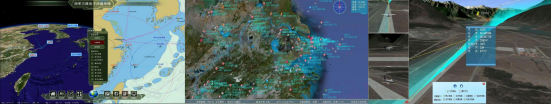
為達到電子沙盤與真實環境穩定融合的效果,例如基於多AI的方法建構多通道互動系統,為指揮人員提供更有效率、更自然的互動方式,進而提高指揮人員的指揮效率。 實現全要素、多種類、多層級、多粒度的三維實景全像展現,為指揮者提供直覺逼真的戰場態勢要素,提供多視角多方位觀察態勢的能力,有助於掌握全局,確保作戰任務的順利 及時完成,提升作戰效能。 軍事繪標電子沙盤是以自然互動(包括語音、動作、手勢、視線等)、擴增實境、協同標繪等技術為基礎,為不同角色的指揮作戰人員在真實指揮所中進行虛實互動、協同研討 、共同標繪、制定方案等提供技術支撐,將成為電子沙盤跨越式發展的強勁動力。
某司研發的多維互動式軍事繪標電子沙盤從實戰角度出發,在兼容傳統物理沙盤地形描述功能、繼承傳統電子沙盤地理資訊顯示功能的基礎上,面向高級指揮人員的作戰、訓練需求,重點實現 電子沙盤和指揮中心其他操作席位的互聯互通,設計提出了一套戰時用於指揮作戰、平時用於演訓演練的智能化互動式指揮訓練作業平台。
戰時,電子沙盤作為首長指揮作戰的顯控終端,融合各操作席位作戰要素保障信息,實時接收戰場信息,顯示戰場二三維態勢圖,提供標繪、測量、計算等基礎輔助手段,同時基於數據 挖掘、人工智慧技術,為首長提供可智慧學習調整的作戰預案並進行推演仿真,輔助首長定下作戰決心。 平時,電子沙盤作為首長演訓演練的指控終端,具備想定設定、訓練導調功能,支援訓練想定從制定、部署到訓練全過程的資料記錄、輔助評估、複盤推演及歷史資料查詢。 同時也可作為指揮中心機關部隊人員交流、訓練的研究平台及部隊軍情資訊發布、展示、應用的服務平台。
某司研發的多維互動式軍事繪標電子沙盤是基於二維地理資訊平台和三維數位地球,結合多媒體顯控技術、模擬視覺化技術、網路通訊技術、海量資料管理技術及多點觸控技術於一體 的新型的二三維互動式軍事模擬與模擬一體化平台。

軟體平台是電子沙盤系統的核心,其工作原理是接入多源外部數據,融合處理和存儲數據,基於業務需求分析數據,二三維動態展示數據。 因此,資料處理平台是基礎,資料存取平台和視覺化顯示平台是支撐。 視覺化顯示終端是電子沙盤最直覺的認知形象,包括行動端、桌面端和大螢幕顯示終端。 其中大螢幕顯示終端可支援多點紅外線觸控,是實現人機互動的主要形式。
军用交互式电子沙盘系统工作原理图
(一)基础设施层
基础设施层是支撑系统运行的基础环境,包括图形工作站、存储设备、计算设备、网络设备、显示设备、操作系统等,为原型系统提供统一、高速、安全的网络和主机运行基础平台。
(二)基础服务层
基础服务层是系统的数据资源承载与基础服务提供层,对上支撑平台应用层,提供数据库管理系统、通信管理器、特定引擎等基础功能,并在此基础上开发提供业务相关的基础服务。核心服务包括地理信息服务、数据接入服务、态势显示服务、仿真推演服务、互联互通服务、军标标绘服务等等,服务类型可根据需求进行定制开发,满足不同业务应用需求。
(三)平台应用层
包括业务平台和面向用户的应用类插件。业务平台包括数据接入平台、数据处理平台、可视化显示平台。
(四)数据接入平台
用于接入、处理、存储、分发各类型信息,构建自定义的专业军情数据库。具体表现为:能够接收不同来源、格式、特点的作战过程、综合保障、地理信息、仿真推演等数据,并在逻辑或物理上有机综合集成,为态势显示、作战研讨、指挥决策、训练评估等不同应用提供数据支撑。在平时,收集各类军用基础信息,如装备信息、人员信息、阵地信息、目标信息、作战方案等,处理为可供数据处理平台调用的数据格式,以本地存储或云存储的形式保存;在战时,实时引接指挥中心各操作席位的气象水文、电磁环境、地理环境、人文环境数据,战场中人员和装备的实时位置及属性、北斗信息、视频信息等,并处理为可供数据处理平台调用的数据格式。
(五)数据处理平台
以地理信息数据为背景,接收或调用数据接入平台的各类数据,构建态势一张图,实现敌情、我情、战场环境、目标分析、行动进程、标绘和干预过程可视化。在此基础上,提供标准化接口,与其他系统实现有效数据衔接,保障功能扩展和其他系统接入,支持业务应用插件定制开发,为作战指挥业务扩展提供支撑。在平时,基于积累的数据构建仿真战场态势,制定作战计划和方案,进行演习训练和仿真推演,相关成果存入数据接入平台,供战时调用。
(六)可视化显示平台
基于自主化三维仿真引擎实时渲染生成与作战及训练区域一致的三维战场环境,运用结构化数据技术及灵活可编辑的逻辑数据模型,实现“图层化”信息数据融合显示及输出,并实现多点红外触摸控制及语音控制等。
(七)平台插件
相关插件是针对作战规划需求进行设计,包括数据引接与管理类、过程分析与展示类以及方案推演与评估类的功能插件,定制实现了作战规划业务数据的引接和综合管理。作战过程中战场环境与战场态势的“一幅图”综合展示,以及作战过程涉及的侦察、部队行动、战场防抗和火力打击各类方案的综合仿真推演与展示。
三、系统组成
(一)数据引擎
1.数据多样
支持海量、多源数据处理,主要包括:影像、矢量、DEM、三维模型、海图、陆图、空图等;
2.数据更新
支持多级混合精度地理数据的快速更新;
3.数据分发
支持基于C/S模式的数据分发,快速构建电子沙盘;
4.数据访问
支持多源海量数据的分布式部署和访问,可以访问云端数据。

(二)綜合顯控
1.全空間表達
支援全空間、多視角、多粒度模擬視覺化表達;
2.二維一體化
支持二維一體化可視化表達;
3.多點觸控
支援基於多點觸控技術的新型人機互動方式;
4.互動式標註
支援三維模型、地標、路徑、區域、360 全景圖的互動式標註和多媒體資訊的掛載。

(
三)沙盤態勢
1.態勢可視化
支援多目標、多批次戰場態勢視覺化,並具備場景的保存、回放等功能;
2.多樣化資料來源
相容於 GPS、北斗、雷達、AIS 等多源監視數據,並具備可擴展數據介面;
3.編輯與推演
支持態勢場景的二維一體化編輯與推演;
4.態勢特效庫
具備火焰、爆炸、煙霧、紅外線、電磁、雷達等種類豐富戰場模擬效果庫。

(四)軍標標繪
1.協同標繪
支援多人多客戶端同步和非同步協同軍事標繪;
2.二三維標繪
支援軍標的二立體同步標繪和編輯;
3.草圖示繪
支援草圖智慧識別標繪;
4.同畫面標繪
支援多人同屏三維模型標繪和編輯;
5.軍標推演
具備二三維軍標態勢推演功能。
(五)仿真引擎
1.自然環境仿真
專業的遊戲級渲染,支援立體雲、霧、雨、雪、海水等自然環境模擬;
2.氣象數值模擬
支援大尺度、多源戰場氣象環境資料的高效處理、解析和數值模擬;
3.仿真推演
以人機互動的方式對推演目標進行部署、推演,可擴展模擬演算法與作戰規則等;
4.效果評估
支援對作戰效果的評估。

(六)协同研讨
1.电子白板
基于电子白板的分布式协同研讨和标绘,支持常规图形、军标、多媒体文件等;
2.视频会议
具备基于文字、语音、视频通讯的会议室模式协同研讨功能,提高沟通效率;
3.文件共享
支持 txt、PPT、PDF、图片文件、压缩文件、视频等文件共享。

(七)軟硬體一體化
支援與桌面互動硬體的完美結合;
支援與多點觸控硬體完美結合;
支援與視訊會議系統硬體的整合;
支援跨平台應用程式。
(八)關鍵功能指標
具備現有航警資訊偵察系統的顯示效果、故障模擬、資料引接功能;具備世界海空區域劃分顯示、防空識別區功能;
具備將現有業務數據,基於專業的知識學習模板,快速配置成學習資源、快速配置成學習資源和學習時長的能力;
具備沙盤推演預置多種場景,多種國別,包括美國、印度、日本等等國家;
支援多源海量資料儲存、處理和更新功能。
(九)優勢特色
1.完整的行業解決方案
電子沙盤解決方案涉及沙盤資料的處理、導入、更新、沙盤資訊共享、協同工作、指揮決策、軍事標繪、模擬模擬、沙盤推演等相關內容,功能之間保持相對獨立,可根據用戶需求定制個性 化的解決方案,滿足使用者多樣化的需求;
2.海量資料管理能力
地理資訊數據是電子沙盤的核心,資料引擎可對多源、海量的地理資訊數據進行儲存、處理和更新,支援資料的分散部署,能夠存取雲端數據, 為沙盤的建置提供低成本、高效的 數據來源;
3.一體化應用
實現了軟體與硬體一體化的完美結合,支援多點觸控螢幕、指揮控制台位、環形投影幕、專用顯控台位、生產監控平台等多種硬體平台;軟體實現了二維一體化應用 ,並且整合了視訊會議、網路通訊、軍事標繪等功能,是一款多功能綜合性電子沙盤系統;
4.良好的開放性和相容性
系統架構設計合理,具有良好的組織結構和易用的開發介面;具備與硬體良好的兼容性,可進行二次開發和功能擴展,能夠與其它的軟體系統快速整合。
四、結束語
隨著資訊化建設的深入,資訊來源與種類的日益擴展,決策支援手段的不斷豐富,針對各軍兵種作戰訓練、指揮決策的需要,建立一套具備完整的指揮決策分析、任務推演及態勢展示 功能的電子沙盤系統成為當務之急。 針對BD需求,某司研發了的這套電子沙盤系統具備綜合態勢展示直觀、交互手段豐富多樣、作戰數據引接靈活、功能齊全兼具擴展,可滿足首長的作戰指揮和指揮訓練的使用需求。
Citation: Wang Xue, Ju Xiaojie, Wang Duo, et al. Design of military interactive electronic sandbox system for actual combat
中國軍事資源:https//www.81it.com/2024/0103/14888.html